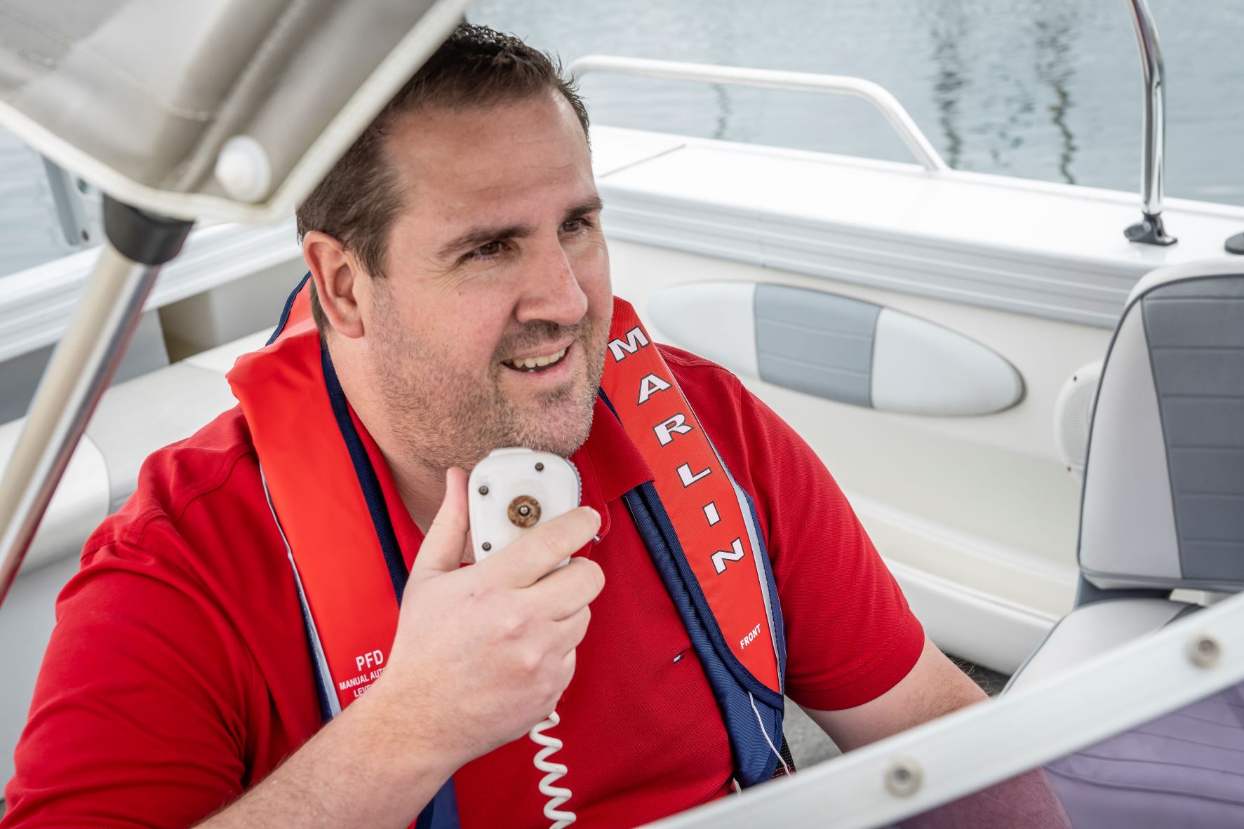
Marine radio
The possibility that a marine radio may save your life is the best reason to install one in your boat and learn how to operate it. You can use your marine radio to:
- Monitor distress frequencies.
- Contact other vessels if you need help.
- Contact shore-based stations that can co-ordinate a rescue.
- Keep you up-to-date with weather information and navigational safety warnings.
Marine radios are required on vessels if you are operating in unprotected waters more than 2 nautical miles from the coastline but can also be used closer to shore.
Types of marine radio
There are three types of marine radio available:
27 MHz marine
27 MHz marine radios, commonly called 27 'meg', are popular for use on recreational boats and provide short-range communications, but not the range or performance of a VHF radio.
They would be suitable for operating in protected and semi-protected waters or in unprotected waters within the range of a coast station. 27 MHz marine radios do not need to be licensed and no operator's licence is required to use one.
27 MHz marine may be monitored by other recreational vessels or at various locations and hours of operation by Volunteer Marine Rescue radio bases.
VHF marine
VHF marine transceivers provide better short-range communications than a 27 MHz radio.
They are suitable for operating in protected and semi-protected waters or in unprotected waters within the range of a coast station or a VHF marine repeater station.
An operator's licence is required to use a VHF marine radio but no licence is needed to have one fitted on your boat.
VHF channel 16 distress and safety messages:
- Distress and safety messages are transmitted on VHF channel 16.
- You should monitor channel 16 to listen for distress calls from other boats.
- VHF channel 16 is monitored 24 hours per day.
- All commercial ships operating at sea are required by law to carry and monitor VHF channel 16.
- VHF channel 16 and repeater channels may be monitored by other recreational vessels, and at various locations and hours of operation by Volunteer Marine Rescue radio bases.
MF/HF marine
MF/HF marine transceivers offer medium to long-range communications.
Installation of a:
- MF/HF transceiver capable of operating on the HF marine voice distress frequencies is highly recommended where operating in unprotected waters up to 200 nautical miles offshore
- HF DSC (GMDSS compliant 4.64MB) marine transceiver is recommended when vessels operate more than 200 nautical miles offshore.
Services available on HF radio include:
- Modernised Australian Ship Tracking and Reporting System (MASTREP)
- Bureau of Meteorology marine weather forecasts and warnings
An operator's licence is required to use a MF/HF marine radio and a licence is also required to have one fitted on your boat. The boat will be issued with an official Australian marine radio callsign for use with the MF/HF radio. Commercial vessels are required to carry a copy of the Marine Radio Operator's Handbook on their boat at all times. It is recommended you do so. It is available for a small charge from the Australian Maritime College.
Training and licence requirements for radio operationIn a boating emergency you must know how to call for help or recognise when another boat is calling for help. You should be familiar with standard radio procedures that are used by vessels of all nationalities, including distress frequencies and calls. Make sure you have appropriate licences from the Australian Maritime College.
| Type of radio | Marine radio licence | Operator's certificate |
|---|---|---|
| 27 Mhz | No | No |
| VHF |
No* * unless Digital Select Calling enabled | Yes |
| MF/HF | Yes | Yes |
Operate, check and test marine radios
The possibility that a marine radio may save a life is the best reason to install one in your boat. It is specifically designed for the marine environment. You can use your marine radio to:
- monitor distress frequencies
- contact other vessels if you need help
- contact shore-based stations that can co-ordinate a rescue
- keep you up-to-date with weather information and navigational safety warnings.
Basic marine radio operating etiquette includes:
- using standard radio procedures
- always identifying yourself on air
- being familiar with your radio equipment
- being brief and mindful of your language
- listening before you talk
- always monitoring relevant distress frequencies.
Checking marine radio
Use the normal call and reply procedures for radio checks and follow these steps until you make a successful test radio transmission to Coast Radio Services.
1. Before transmitting, listen
Before transmitting, listen for a period long enough to be satisfied that harmful interference will not be caused to communications already in progress.
2. When establishing communication
When establishing communication, calls should be made like this:
- speak the name, call sign or other identification of the station no more than three times
- use the words - 'This is …' to identify yourself
- for a second time - speak the name, call sign or other identification of the station no more than three times
- say 'This call…' immediately followed with the purpose of the call, and the word "over" (this is the invitation for the Coast Radio station to respond).
For example:
'Coast Radio Adelaide Coast Radio Adelaide Coast Radio Adelaide. This is spindrift vlw1234 spindrift vlw1234 spindrift vlw1234.
Radio check requesting acknowledgement on frequency [say frequency].'
3. If the coast radio station does not respond
If the coast radio station being called does not respond:
- wait one minute
- check that your transmission will not interfere with any other communication
- providing the frequency is clear - repeat the test transmission twice.
4. If the coast station still does not reply
If the coast station still does not reply (to a call sent three times in the space of two minutes) stop calling and try again after an interval of three minutes.
5. Still no response
If there is still no response try another frequency.
6. No response received - check
Should no response be received - check:
- radio and tuning settings
- radio and antenna connections
- then attempt the test transmission again
- repeat these steps process until you are successful.
If you are not successful, you'll need to identify and fix the problem prior to departing on your trip.
Testing marine radio transmissions
When you need to transmit marine radio signals for testing or technical adjustments:
- Undertake a marine radio check procedure.
- Make sure that it will not interfere with any communications traffic.
- Keep test signals to a minimum, particularly on frequencies used for distress, emergency and safety purposes.
- You can make brief transmissions to confirm that equipment is operating properly before starting a sea trip.
Coast Radio Adelaide monitors test transmissions seven days a week and will provide advice about quality of the transmission according to the standard readability.
| Readability | Description |
|---|---|
| 1 | Unreadable |
| 2 | Readable now and then |
| 3 | Readable but with difficulties |
| 4 | Readable |
| 5 | Perfectly readable |
VHF marine radio coverage
The maps and information on this page provide a snapshot of the VHF radio channels and coverage for each region.
Map legend
- Green = areas where high quality reception should exist
- Grey = areas where marginal reception should exist
- Elsewhere = areas where coverage will not normally exist.
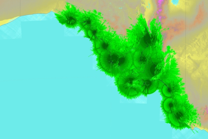
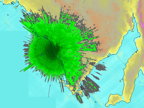
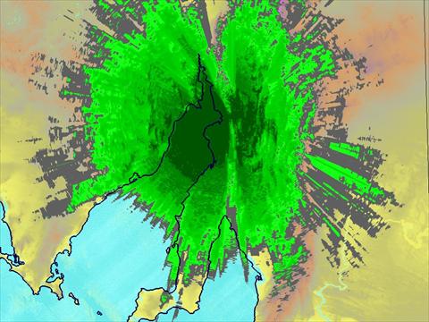
Coast Radio Adelaide - VHF Ch 16 Marine Safety
This radio distress and safety service provides a 24-hour safety net on Channel 16 for vessels that may require urgent assistance.
It uses VHF marine radio equipment located at 14 South Australian Government Radio Network sites. Operating as Coast Radio Adelaide, this service is monitored during the day (7.00 am to 7.00 pm) by volunteers at the South Australian Sea Rescue Squadron's radio base at West Beach and at night (7.00 pm to 7.00 am) by Flinders Ports.
Coverage extends from west of Fowlers Bay through into Victorian waters and includes all Gulf Waters, including coastal waters surrounding Kangaroo Island. The green area on the map shows where high quality reception should exist.
Coverage:
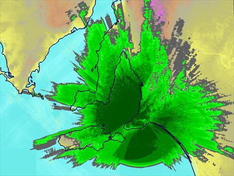
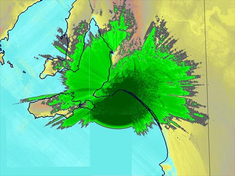
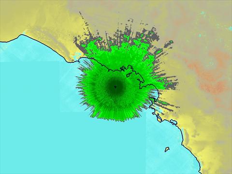
Myponga - Ch 80 VHF marine radio repeater
This VHF marine radio repeater operates on Channel 80 and is located at Myponga Hill on the Fleurieu Peninsula.
It provides coverage of Gulf St Vincent, Investigator Strait, Backstairs Passage and over the Lower Murray and Lakes.
Predicted coverage:
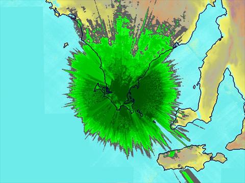
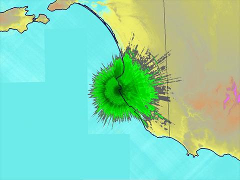
Elliston - Ch 80 VHF marine radio repeater
This VHF marine radio repeater operates on Channel 80 from Bramfield on Eyre Peninsula (approx 5 nautical miles north east of Elliston).
It provides coverage of coastal waters to the west of Eyre Peninsula between Port Lincoln (Ch 81) repeater and the St Francis Island (Ch 82) repeater.
Coverage:
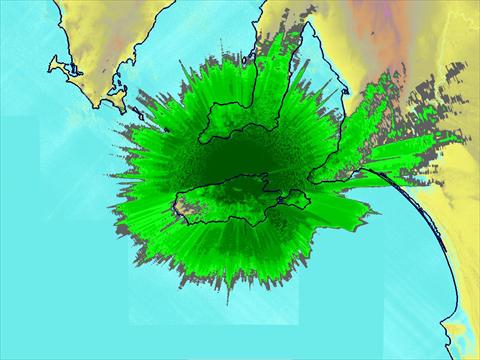
Kerby Hill - Ch 83 VHF marine radio repeater
This VHF marine radio repeater operates on Channel 83 and is located at Kerby Hill on the Fleurieu Peninsula (approximately three nautical miles North of Port Elliot).
It provides coverage of local coastal waters surrounding the lower Fleurieu Peninsula, over the Lower Murray and Lakes, extending down to the South East including the northern waters of the Coorong.
Predicted coverage:
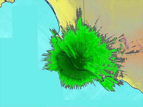
Port Lincoln - Ch 81 VHF marine radio repeater
This VHF marine radio repeater operates on Channel 81 at Greenpatch on lower Eyre Peninsula (approximately 9 nautical miles North West of Port Lincoln).
It provides coverage of southern Spencer Gulf waters and coastal waters around Eyre Peninsula including Coffin Bay.
Predicted coverage:
Kangaroo Island - Ch 21 VHF marine radio repeater
This VHF marine radio repeater operates on Channel 21 and is located on Kangaroo Island at Mt McDonnell (approximately three nautical miles South West of Cape Cassini on the northern coast).
Coverage is provided between the Port Lincoln Ch 81 and Adelaide Ch 80 repeaters across Investigator Strait and Kangaroo Island coastal waters.
Predicted coverage:
Port Pirie - Ch 82 VHF marine radio repeater
This VHF marine radio repeater operates on Channel 82 and is located on The Bluff (approximately 9 nautical miles to the North East of Port Pirie)
It provides coverage of northern Spencer Gulf waters.
Predicted coverage:
Robe - Ch 82 VHF marine radio repeater
This VHF marine radio repeater operates on Channel 82 at Robe in the South East. It provides coverage of local coastal waters in the Robe area.
Predicted coverage:
South East - Ch 22 VHF marine radio repeater
This VHF marine radio repeater operates on Channel 22 and is located in the South East at The Bluff (approximately 12 nautical miles North West of Mount Gambier). It provides coverage of coastal waters in the South East between the Robe Ch 82 and Portland (Victoria) Ch 81 repeaters.
Predicted coverage:
St Francis Island - Ch 82 VHF marine radio repeater
This VHF marine radio repeater operates on Channel 82 and is located on St Francis Island (approximately 30 nautical miles South West of Ceduna). It provides coverage of local coastal waters up to approximately 60 nautical miles offshore from Ceduna including Murat Bay, Denial Bay and Smoky Bay.
Distress frequencies and calls
| Marine radio transceiver | Distress frequency |
|---|---|
| 27 MHz |
27.88 MHz (Channel 88) with 27.86 MHz (Channel 86) as a supplementary |
| VHF | Channel 16 with Channel 67 as a supplementary |
| MF/HF |
2182, 4125, 6215 and 8291 kHz Note: the Coast Stations operated by the States and the NT do not monitor 2,182kHz however volunteers may. |
Making a call
| Call type | What to say | Information given |
|---|---|---|
Distress call
| May-day |
|
Safety call
| Example 1 Say cure-e-tay 'This is (name and radio call sign of vessel or shore station)' spoken three times. Example 2 say cure-e-tay |
|
Urgency call
| Pan-pan 'This is (name and radio call sign of vessel)' spoken three times. |
|
Each transmission should end with the word 'over' to indicate you are expecting the other station to reply.
Always end the exchange of communications with the word 'out'.
When reception is doubtful or conditions difficult spell out word and figures using the International Phonetic Alphabet:
| Alphabet | Phonetic word |
|---|---|
| A | ALPHA |
| B | BRAVO |
| C | CHARLIE |
| D | DELTA |
| E | ECHO |
| F | FOXTROT |
| G | GOLF |
| H | HOTEL |
| I | INDIA |
| J | JULIETT |
| K | KILO |
| L | LIMA |
| M | MIKE |
| N | NOVEMBER |
| O | OSCAR |
| P | PAPA |
| Q | QUEBEC |
| R | ROMEO |
| S | SIERRA |
| T | TANGO |
| U | UNIFORM |
| V | VICTOR |
| W | WHISKEY |
| X | X-RAY |
| Y | YANKEE |
| Z | ZULU |
Navigational warnings and weather broadcasts
Marine weather information is broadcast by the Bureau of Meteorology and navigation warnings are broadcast twice daily on 8176 kHz by the Coast Radio network at scheduled times.
Marine weather broadcasts
Marine weather information, routine forecasts, and warnings are broadcast by the Bureau of Meteorology through HF radio transmitters at:
- Charleville in Queensland (Callsign VMC)
- Wiluna in Western Australia (Callsign VMW).
Warnings are broadcast on the half-hour, every hour from both sites.
VMC Charleville broadcasts
| Routine coastal weather forecasts for South Australia at these times: 0200, 0600, 1000, 1400, 1800, 2200 CST | Frequencies for night CST 1730 to 0630 | Frequencies for day CST 0630 to 1730 |
|---|---|---|
| VMC frequencies (kHz) |
2201 6507 8176 12365 |
4426 8176 12365 16546 |
VMW Wiluna boadcasts
| Routine coastal weather forecasts for South Australia at these times: 0300, 0700, 1100, 1500, 1900, 2300 CST | Frequencies for night CST 1930 to 0830 | Frequencies for day CST 0830 to 1930 |
|---|---|---|
| VMC frequencies (kHz) |
2056 6230 8113 12362 |
4149 8113 12362 16528 |
For more information about marine weather services, including a radio fax service:
- visit www.bom.gov.au/marine
- phone 08 8366 2600.
HF Safety communications
Charleville Radio and Wiluna Radio monitor distress calls on the frequencies below.
Please remember to limit the use of these frequencies to distress and safety situations.
| Frequency (KHz) | Purpose |
|---|---|
|
4125 6215 8291 | Distress, urgency, safety and calling only, 24 hours a day |
| 12290 |
Distress, urgency and safety only Monitored from 0700 to 1900 local time (0800 to 2000 during daylight saving) |
|
4146 6227 8294 | Safety working channels |
The rule of thumb for high-frequency radio is to use the higher frequencies during the day and the lower at night. The best frequency for the time of day is likely to be:
- 8291 - during the day
- 4125 - at night
- 6215 - as the next choice for either day or night.
More accurate predictions can be found on the Bureau of Meteorology's Space Weather Service website by selecting:
- Hourly Area Prediction charts (HAP charts) show the area covered by each frequency for that time of the day for locations in South Australian coastal waters by each of the Charleville or the Alice Springs HF radio sites.
- Hourly Network Area Prediction charts (NAP charts) show the best frequency for that time of the day for locations in South Australian coastal waters used to call either Charleville Radio or Wiluna Radio.
These charts are updated on an hourly basis.
If your vessel is fitted with an HF marine radio it's important to check that these frequencies are available so you can access these distress and safety services.
Navigation warnings
Navigation warnings are broadcast twice daily on 8176 kHz by:
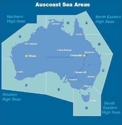
- Coast Radio Adelaide will broadcast warnings for areas D and F, at 1255 and 1455 Central Standard Time (CST) (0325 and 0725 Universal Time Coordinated (UTC)).
They will also cover warnings for Auscoast Area E if time permits.
Warnings for Auscoast Area E (South Australia) may also be broadcast by:
- Coast Radio Melbourne at 0755 and 1155 CST (2125 and 0225 UTC)
- Coast Radio Perth at 1555 and 2055 CST (0625 and 1025 UTC).
Individual stations will broadcast urgent, local navigation warnings at the earliest available opportunity.
For Auscoast Sea Areas, please refer to the map below.